About CEZA
Investments & Opportunities in Cagayan Special Economic Zone and Freeport
The Cagayan Economic Zone Authority (CEZA) is a government owned and controlled corporation that was created by virtue of Republic Act 7922, otherwise known as the “Cagayan Special Economic Zone Act of 1995″. It was authored by Senator Juan Ponce Enrile, a native of Cagayan Province, and approved by then President Fidel V. Ramos. It has been tasked to manage and supervise the development of the Cagayan Special Economic Zone and Freeport (CSEZFP).
From 1997 up to the present, CEZA continues to initiate several projects to promote development in the CSEZFP. As an economic zone, it aims to develop the whole area into a self-sustaining industrial, commercial investment, financial and tourism-recreational center and, likewise, with suitable retirement / residential areas. As a Freeport, it operates as a separate customs territory similar to Hong Kong, Singapore, Lubuan in Malaysia and Hamburg in Germany. It is envisioned to be a major transshipment point for trade in the Asia-Pacific rim. In this light, it now opens itself to interesting business opportunities with attractive incentives and advantages for interested investors that would like to register in CEZA. These developments are all deemed toward attracting legitimate and productive local and foreign investments and, thus, creating employment opportunities in and around the Freeport.

Our Location
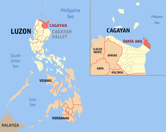
The Cagayan Special Economic Zone and Freeport (Cagayan Freeport) is located at the northeastern tip of the Philippines surrounded by the waters of Balintang Channel, China Sea and the Pacific Ocean. It covers the entire Muicipality of Sta. Ana and the Islands of Fuga, Barit, Mabbag in the Municipality of Aparri in the Province of Cagayan – with approximately 54,118.95 hectares of urban, suburban and agro-industrial lands for prime development.
It is strategically located between the Pacific Ocean and China Sea and enjoys proximity to lucrative overseas market such as Taiwan, HongKong, japan, Korea, and the People’s Republic of China. It is in fact situated at the crossroads of international shipping routes between the West Coast of North America, Far East and Southeast Asia.
The Cagayan Freeport operates as a separate customs territory similar to Hong Kong, Singapore, Lubuan in Malaysia and Hamburg in Germany.
The Cagayan Freeport is approximately a 45-minute flight from Kaoshiung Taiwan’s largest industrial and shipping center, and only a few minutes longer from Hong Kong.
Region II
Population: 3,685,744 (per 2020 census)
Population Growth Rate: Annual growth rate of 1.39%
Major Industries: Agriculture, Fishery and Forestry, Community and Social Services; Wholesale and Retail Trade; Manufacturing.
SANTA ANA
Land Area: approximately 441.3 square kilometers representing 4.90% of the total area of Cagayan.
Physical/Political Boundaries: Bounded on the north and east by Pacific Ocean, on the west by the Babuyan Island and on the south by the municipality of Gonzaga.
Political Districts/Barangay: 16 Barangay

Quick Facts about Region II and Cagayan
Land Area
Cagayan Province, including the Babuyan Island Group, is approximately 900,270 hectares, the second largest in terms of land area in Region II, and constitutes about 3% of the total land area of the Philippines.
Physical/Political Boundaries
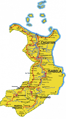
The Balintang Channel, North of the Babuyan Islands, forms the boundary between the provinces of Cagayan and Batanes. The northern portion of Cagayan mainland opens to the China Sea, and on the east it faces the Philippine Sea. The Sierra Madre Mountains froms its rugged and mountanous eastern coast. Cagayan is bounded on the south by the Province of Isabela. The Cordilleras enclose its southwestern part, bordering on the Province of Kalinga, and its northeastern part bordering on the Province of Apayao.Political Districts/Barangays: 1 city, 28 municipalities with Tuguegarao City serving as the provincial city capital.
INVESTMENT OPPORTUNITIES
VISITOR COUNTER
 0ki.group/wp-content/plugins/xt-visitor-counter/styles/image/chevy/7.gif' alt='7'>
 0ki.group/wp-content/plugins/xt-visitor-counter/styles/image/chevy/7.gif' alt='7'>.u
 0ki.group/wp-content/plugins/xt-visitor-counter/styles/image/chevy/6.gif' alt='6'>41
 0ki.group/wp-content/plugins/xt-visitor-counter/styles/image/chevy/7.gif' alt='7'>
 0ki.group/wp-content/plugins/xt-visitor-counter/styles/image/chevy/7.gif' alt='7'>.u
 0ki.group/wp-content/plugins/xt-visitor-counter/styles/image/chevy/4.gif' alt='4'>
 0ki.group/wp-content/plugins/xt-visitor-counter/styles/image/chevy/7.gif' alt='7'>
 0ki.group/wp-content/plugins/xt-visitor-counter/styles/image/chevy/7.gif' alt='7'>
 0ki.group/wp-content/plugins/xt-visitor-counter/styles/image/chevy/7.gif' alt='7'>
 0ki.group/wp-content/plugins/xt-visitor-counter/styles/image/chevy/7.gif' alt='7'>.u
 0ki.group/wp-content/plugins/xt-visitor-counter/styles/image/chevy/6.gif' alt='6'>
 0ki.group/wp-content/plugins/xt-visitor-counter/styles/image/chevy/7.gif' alt='7'>
 0ki.group/wp-content/plugins/xt-visitor-counter/styles/image/chevy/7.gif' alt='7'>.u
 0ki.group/wp-content/plugins/xt-visitor-counter/styles/image/chevy/6.gif' alt='6'>41
 0ki.group/wp-content/plugins/xt-visitor-counter/styles/image/chevy/7.gif' alt='7'>
 0ki.group/wp-content/plugins/xt-visitor-counter/styles/image/chevy/7.gif' alt='7'>.u
 0ki.group/wp-content/plugins/xt-visitor-counter/styles/image/chevy/4.gif' alt='4'>1
 0ki.group/wp-content/plugins/xt-visitor-counter/styles/image/chevy/7.gif' alt='7'>
 0ki.group/wp-content/plugins/xt-visitor-counter/styles/image/chevy/7.gif' alt='7'>.u
 0ki.group/wp-content/plugins/xt-visitor-counter/styles/image/chevy/3.gif' alt='3'>
 0ki.group/wp-content/plugins/xt-visitor-counter/styles/image/chevy/7.gif' alt='7'>
 0ki.group/wp-content/plugins/xt-visitor-counter/styles/image/chevy/7.gif' alt='7'>.u
 0ki.group/wp-content/plugins/xt-visitor-counter/styles/image/chevy/6.gif' alt='6'>
 0ki.group/wp-content/plugins/xt-visitor-counter/styles/image/chevy/7.gif' alt='7'>
 0ki.group/wp-content/plugins/xt-visitor-counter/styles/image/chevy/7.gif' alt='7'>.u
 0ki.group/wp-content/plugins/xt-visitor-counter/styles/image/chevy/6.gif' alt='6'>41
 0ki.group/wp-content/plugins/xt-visitor-counter/styles/image/chevy/7.gif' alt='7'>
 0ki.group/wp-content/plugins/xt-visitor-counter/styles/image/chevy/7.gif' alt='7'>.u
 0ki.group/wp-content/plugins/xt-visitor-counter/styles/image/chevy/4.gif' alt='4'>1
 0ki.group/wp-content/plugins/xt-visitor-counter/styles/image/chevy/7.gif' alt='7'>
 0ki.group/wp-content/plugins/xt-visitor-counter/styles/image/chevy/7.gif' alt='7'>.u
 0ki.group/wp-content/plugins/xt-visitor-counter/styles/image/chevy/2.gif' alt='2'>
 Users Today : 560
 Users Yesterday : 741
 This Month : 2010
 This Year : 54799
 Total Users : 477392
 Views Today : 2336
 Total views : 3830695
REPUBLIC OF THE PHILIPPINES
ABOUT GOVPH
Learn more about the Philippine government, its structure, how government works and the people behind it.


